LONDON (Reuters) – El Niño conditions are developing across the Pacific Ocean, with meteorologists now putting the probability of a full event developing by the end of the year at almost 75 percent.

FILE PHOTO – Downtown Los Angeles skyline is seen in front of the snow covered San Gabriel Mountains following a series of El Nino driven storms in Los Angeles, California January 7, 2016. REUTERS/Bob Riha Jr.
John Kemp
October 10, 2018
Sea surface temperatures are warming counter-seasonally across much of the equatorial Pacific and trade winds are slackening, both common precursors of an El Niño episode.
The principal impacts of El Niño (and its opposite weather pattern La Niña) are felt in Southeast Asia, Australia and South America, where it can have a major effect on temperatures and rainfall, with a big effect on agriculture.
The impacts on North America are more complicated and variable, but it has an effect on both total heating demand and its regional distribution in the winter months.
El Niño conditions alter the position of the polar jet stream, typically bringing warmer temperatures to Canada and the northern United States during the northern hemisphere winter from December to February.
But El Niño also results in a stronger and more persistent Pacific jet stream into the southwestern United States, bringing more rain, snow, storms and cooler temperatures to California and other southern states.
As the ocean warms, government forecasters in the United States and Australia estimate there is now triple the normal chance of El Niño occurring this winter, though it is likely to be a relatively weak episode.
ENSO CIRCULATIONS
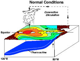
El Niño is one aspect of the enormous ocean-atmosphere circulations that transport heat across the equatorial Pacific, a set of complex interactions known formally as the El Niño-Southern Oscillation (ENSO).
In the oceanic circulation, cool water wells up from the deep sea off the coast of Peru and is transported west across the Pacific on the equatorial current towards the maritime continent of Southeast Asia.
The water is gradually warmed by the wind and sun ultimately forming a pool of very warm water off the coast of Indonesia.
There is a return flow of warm water east to South America on the equatorial counter currents and in a deep current below the surface of the ocean, closing the loop.
At the same time, warm water around the maritime continent causes tremendous evaporation and a column of warm moist air to rise high into the atmosphere, which then flows east across the Pacific.
The air cools and dries, eventually sinking off the coast of South America, before returning towards Asia in a steady westward flow near the surface known to mariners as the trade winds.
The oceanic and atmospheric circulations tend to reinforce one another, with the trade winds driving the equatorial currents, and sea surface temperature differentials reinforcing the rising and falling air columns.
But the strength of the circulations and the degree of coupling between them varies at seasonal, annual and inter-annual time scales (El Nino, La Nina and the Southern Oscillation”, Philander, 1990).
El Niño occurs when both circulations are weak, trade winds are slack, less cold water is welling up off the coast of Peru, and less cold water is being carried west into the central Pacific.
La Niña, the opposite of El Niño, occurs when circulations are at their strongest, with strong trade winds, more upwelling and more cold water carried further into the central ocean.
The entire ocean-atmosphere system cycles irregularly between weak, warm El Niño and strong, cool La Niña phases, but the frequency and strength of the phases is highly variable.
As a rule, however, El Niño and La Niña effects tend to be weakest during the first quarter of the year, strengthening in the second and third quarters, and peaking in the fourth.
Forecasts therefore tend to be relatively uncertain and subject to large errors early in the year but become more accurate towards the end of the third quarter and early in the fourth.
FORECAST FOR 2018
For most of this year, sea surface temperatures in the central-eastern Pacific have been warming but remained close to their long-term seasonal average, sending a relatively ambiguous signal (tmsnrt.rs/2OhOLFi).
In recent weeks, however, sea surface temperatures in the central ocean have become much warmer than average for the time of year, sending a clearer sign that El Niño might be developing.
The trade winds across the equatorial Pacific have also been weakening, which should promote further sea surface warming in the weeks ahead and intensify the formation of El Niño conditions.
Australia’s Bureau of Meteorology upgraded its previous El Niño Watch to an El Niño Alert on Oct. 9, warning that El Niño was now three times more likely than normal to occur before the end of the year.
The Climate Prediction Center, part of the U.S. National Oceanic and Atmospheric Administration, estimates there is an almost 75 percent chance of El Niño conditions prevailing between December and February.
El Niño’s impact is felt most strongly around the Pacific and Indian oceans, and becomes fainter further away, where the effects are more likely to be masked by other oceanic and atmospheric developments.
The weather impacts also depend critically on the strength of the El Niño, in other words how much warmer the Pacific becomes compared with the long-term average.
Strong or very strong El Niño episodes, where sea surface temperatures are 1.5 degrees or 2.0 degrees centigrade above the long-term average, will produce a pronounced and readily observable impact on the weather.
A weak El Niño, where sea surface temperatures average just 0.5-0.9 degrees centigrade above the seasonal average, has much less impact on weather patterns and can easily be masked by other developments.
The strength of El Niño is harder to forecast accurately, but episodes that develop relatively late in the year, such as this one, tend to be weaker than those which start to develop earlier.
The U.S. government is currently forecasting central Pacific surface temperatures will be 0.8 degrees warmer than average between December and February, which would produce a relatively weak El Niño this winter and only moderate impacts on the United States.
Categories: Forecasting