Worldwide and Regional Consequences of El Niño
United States
The twists and turns in the ongoing dialogue between ocean and atmosphere in the Pacific can have a ripple effect on climatic conditions in far flung regions of the globe. This worldwide message is conveyed by shifts in tropical rainfall, which affect wind patterns over much of the globe. Imagine a rushing stream flowing over and around a series of large boulders. The boulders create a train of waves that extend downstream, with crests and troughs that show up in fixed positions. If one of the boulders were to shift, the shape of the wave train would also change and the crests and troughs might occur in different places.
Dense tropical rainclouds distort the air flow aloft (5-10 miles above sea level) much as rocks distort the flow of a stream, or islands distort the winds that blow over them, but on a horizontal scale of thousands of miles. The waves in the air flow, in turn, determine the positions of the monsoons, and the storm tracks and belts of strong winds aloft (commonly referred to as jet streams) which separate warm and cold regions at the Earth’s surface. In El Niño years, when the rain area that is usually centered over Indonesia and the far western Pacific moves eastward into the central Pacific, as shown on p. 17, the waves in the flow aloft are affected, causing unseasonable weather over many regions of the globe.


Anomalies of Winter (a) temperature and (b) precipitation during El Niño.
See List of impacts on the U.S. and List of impacts on other countries.
Tropical Pacific
Near the end of each calendar year ocean surface temperatures warm along the coasts of Ecuador and northern Peru. Local residents referred to this seasonal warming as “El Niño”, meaning The Child, due to its appearance around the Christmas season. Every two to seven years a much stronger warming appears, which is often accompanied by beneficial rainfall in the arid coastal regions of these two countries. Over time the term “El Niño” began to be used in reference to these major warm episodes.
El Niño is closely related to a global atmospheric oscillation known as the Southern Oscillation (SO). During El Niño episodes lower than normal pressure is observed over the eastern tropical Pacific and higher than normal pressure is found over Indonesia and northern Australia. This pattern of pressure is associated with weaker than normal near-surface equatorial easterly (east-to-west) winds. These features characterize the warm phase of the SO, which is often referred to as an El Niño/Southern Oscillation (ENSO) episode.
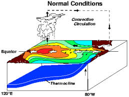
During warm (ENSO) episodes the normal patterns of tropical precipitation and atmospheric circulation become disrupted. The abnormally warm waters in the equatorial central and eastern Pacific give rise to enhanced cloudiness and rainfall in that region, especially during the boreal winter and spring seasons. At the same time, rainfall is reduced over Indonesia, Malaysia and northern Australia. Thus, the normal Walker Circulation during winter and spring, which features rising air, cloudiness and rainfall over the region of Indonesia and the western Pacific, and sinking air over the equatorial eastern Pacific, becomes weaker than normal, and for strong warm episodes it may actually reverse.
The increased heating of the tropical atmosphere over the central and eastern Pacific during warm episodes, affects atmospheric circulation features, such as the jet streams in the subtropics and in the temperate latitudes of the winter hemisphere. The jet streams over the eastern Pacific Ocean are stronger than normal during warm episodes (see seasonal atmospheric circulation features). Also, during warm episodes extratropical storms and frontal systems follow paths that are significantly different from normal, resulting in persistent temperature and precipitation anomalies in many regions.
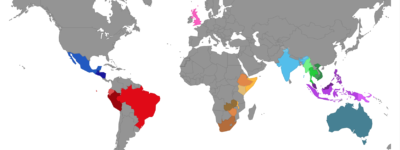
By studying past warm episodes scientists have discovered precipitation and temperature anomaly patterns that are highly consistent from one episode to another. Significant departures from normal are shown in the accompanying figures for the Northern Hemisphere winter and summer seasons. Within the tropics, the eastward shift of thunderstorm activity from Indonesia into the central Pacific during warm episodes results in abnormally dry conditions over northern Australia, Indonesia and the Philippines in both seasons. Drier than normal conditions are also observed over southeastern Africa and northern Brazil, during the northern winter season. During the northern summer season, Indian monsoon rainfall tends to be less than normal, especially in northwest India where crops are adversely affected. Wetter than normal conditions during warm episodes are observed along the west coast of tropical South America, and at subtropical latitudes of North America (Gulf Coast) and South America (southern Brazil to central Argentina).
During a warm episode winter, mid-latitude low pressure systems tend to be more vigorous than normal in the region of the eastern North Pacific. These systems pump abnormally warm air into western Canada, Alaska and the extreme northern portion of the contiguous United States. Storms also tend to be more vigorous in the Gulf of Mexico and along the southeast coast of the United States resulting in wetter than normal conditions in that region.
Australia
Australia’s weather is influenced by many climate drivers. El Niño and La Niña have perhaps the strongest influence on year-to-year climate variability in Australia.
Potential effects of El Niño on Australia include:
- Reduced rainfall
- Warmer than usual temperatures
- Shift in temperature extremes
- Increased frost risk
- Reduced tropical cyclone numbers
- Later monsoon onset
- Increased fire danger in southeast Australia
- Decreased alpine snow depths
Reduced rainfall
The shift in rainfall away from the western Pacific, associated with El Niño, means that Australian rainfall is usually reduced through winter–spring, particularly across the eastern and northern parts of the continent.
Nine of the ten driest winter–spring periods on record for eastern Australia occurred during El Niño years. In the Murray–Darling Basin, winter–spring rainfall averaged over all El Niño events since 1900 was 28% lower than the long-term average, with the severe droughts of 1982, 1994, 2002 and 2006 all associated with El Niño.

Australian winter spring mean rainfall deciles averaged for twelve strong El Niño events.
Although most major Australian droughts have been associated with El Niño, analysis of past El Niño events shows that widespread drought does not occur with every event, and the strength of an El Niño is not directly proportional to the rainfall impacts. For example, during the very strong El Niño that occurred in 1997–98 impacts on rainfall were generally confined to coastal southeastern Australia and Tasmania, while the relatively weak event of 2002–03 saw widespread and significant drought.
Growing season (April–November) rainfall anomalies for eastern Australian plotted against the SOI averaged for April–November for all years from 1900 to 2013, showing the varied effect of both strong and weak El Niño events on rainfall. El Niño is typically associated with sustained negative SOI values.
Warmer temperatures
El Niño years tend to see warmer-than-average temperatures across most of southern Australia, particularly during the second half of the year. In general, decreased cloud cover results in warmer-than-average daytime temperatures, particularly in the spring and summer months. Higher temperatures exacerbate the effect of lower rainfall by increasing evaporative demand. Prior to 2013 (a neutral ENSO year), Australia’s two warmest years for seasonal daytime temperatures for winter (2009 and 2002), spring (2006 and 2002), and summer (1982–83 and 1997–98) had all occurred during an El Niño. The warmth of recent El Niño events has been amplified by background warming trends which means that El Niño years have been tending to get warmer since the 1950s.

Australian winter–spring mean maximum temperature deciles averaged for twelve strong El Niño events.
For complete article, visit Australian Government: Bureau of Meteorology


