A wet winter is forecast for the southern tier of the U.S while drier-than-average conditions are likely in the northern Rockies, northern Plains, and in the Great Lakes states as forecasters say we will have a strong El Nino.
This winter should bring beneficial rain and snow for much of California, while most of the southern United States should see wet, cool weather because of one of the strongest El Niños on record, federal forecasters announced Thursday.
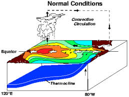
El Niño, a natural warming of Pacific Ocean water that affects weather patterns around the world, should be a major player in both temperature and precipitation, the National Oceanic and Atmospheric Administration (NOAA) said.
“A strong El Niño is in place and should exert a strong influence over our weather this winter,” Mike Halpert, deputy director of NOAA’s Climate Prediction Center, said in a statement.
Halpert called this El Niño one of the strongest on record.
“Confidence continues to grow that this El Niño will be one of the strongest El Niños over the past 50 years,” according to AccuWeather meteorologist Brett Anderson.
Drought-plagued California will benefit from the El Niño, which tends to bring rain and snow, but it may not be enough.
“While it is good news that drought improvement is predicted for California, one season of above-average rain and snow is unlikely to remove four years of drought,” Halpert said. “California would need close to twice its normal rainfall to get out of drought, and that’s unlikely.”
As of Thursday’s U.S. Drought Monitor, 97% of California remains in a drought.
While more precipitation is likely across the southern United States, a winter that is drier than average is forecast for most of Alaska, the northern Rockies, the northern Plains and around the Great Lakes, the prediction center said.
The winter forecast does not specify how much precipitation falls as rain, snow or ice, only that more is likely overall. Snow forecasts depend upon the strength and track of winter storms, which generally cannot be predicted more than a week in advance, the center said.
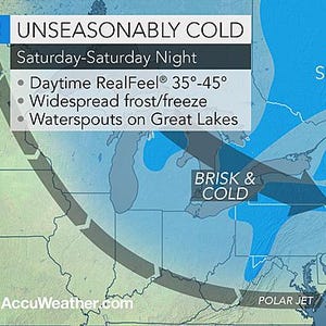
There is a good deal of certainty that the Great Lakes region will get less lake-effect snow than usual, according to AccuWeather.
As for how cold this winter will be, most of the western and northern United States should see milder- than-average temperatures, because weather patterns should keep away the worst of the extended cold outbreaks. But occasional chilly air masses are still likely across the northern tier.
Last year the ocean began generating an El Niño but the atmosphere wouldn’t come to the party. This year the atmosphere is clearly responding.
Two exceptionally large westerly wind events have already occurred in the western equatorial Pacific this year, giving this El Niño a significant boost. Another wind event is forecast for August to kick the system along even further and add to the strength of this El Niño.
What does this mean for Australia?
Of the 26 El Niño events since 1900, 17 have brought widespread drought to Australia. In the big El Niño of 1982, drought devastated the eastern half of Australia and drove the devastating Ash Wednesday bushfires.
In contrast, the even stronger El Niño of 1997–98 brought more localised drought, with key rains in May and September meaning winter crops did reasonably well in most areas. Other years, such as 2002 and 1996, when weaker El Niño’s occurred, the drought was more severe.
For Australia, it’s not the size of El Niño that matters, it’s how it interacts with other rainfall drivers – such as sea surface temperatures around the continent and in the Indian and Southern Oceans, as well as random ‘weather noise’ – that governs the eventual rainfall over the continent.


What can we expect?
A significant El Niño event is currently underway, and there’s a chance it could rival the big events of 1982 and 1997. While this may increase the chance of drought and higher temperatures in eastern Australia, many other factors influence potential impacts.

We are already seeing that in the August–October Bureau of Meteorology seasonal outlooks, with the warmest June ocean temperatures on record in the southern Indian Ocean keeping the strengthening El Niño at bay by putting more moisture into the mid-levels of the atmosphere and changing weather patterns.
So what’s the final 2015 El Niño prediction?
The 2015 El Niño is already significant, and a big El Niño certainly remains a possibility. Widespread strong impacts haven’t (yet) raised their head for Australia and indeed, such as in 1997, may never do.
But managing El Niño is all about managing risk. The southern spring is the time when dry weather, frosts and heatwaves can hurt farmers and many others the most. And that’s when El Niño events, which raise the odds of these impacts, like to bite hardest.
Categories: Forecasting, Weather