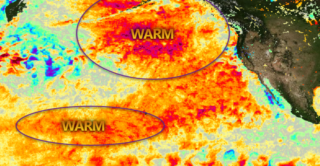
Sea surface temperatures across much of the Pacific Ocean remain unusually warm. There are two critical pockets of warm water that could influence U.S. winter temperature and precipitation patterns.
Oct 23, 2019
Source: Livestock Wx
A good many folks are familiar with the El Niño and La Niña weather events—where warmer or cooler Pacific sea surface temperatures influence weather patterns in the U.S.
There is an alternate, and rarer, type of El Niño that you might not be familiar with called aModoki El Niño, says John Feldt, meteorologist for Livestock Wx.
Modoki is Japanese for “same but different.” Modoki events are a rarer subset of regular El Niño’s and are marked by warmer water centered in the central Pacific. With a Modoki El Niño, the core of strongest warming is located within the center of the Pacific.
Typically, climatologists monitor El Niño sea surface temperatures a little closer to the U.S. That region of the Pacific is considered inactive. A little further west, however, the story is different. And long-range climate model forecasts above-normal sea surface temperatures to persist across the Central Pacific through the winter months.
Possible winter impacts
Assuming little change in current sea surface temperature departures, it’s possible that winter precipitation impacts could align with a Modoki El Niño. A linkage between warm tropical water and the sub-tropical jet stream, via convection, could steer moisture across Mexico and toward the South Central U.S.
This would result in an unusually-dry California and an increase in winter precipitation over the Southeast and the Eastern U.S.
This year’s blob (yes, that’s a weather term) of unusually-warm North Pacific sea surface temperatures is the second largest marine heatwave recorded in the Pacific in at least the last 40 years, covering 4 million square miles. The abnormally warm waters extend from Alaska to Canada and as far west as Hawaii. That includes a large swath of water that’s more than 3 degrees Celsius (5.4 degrees Fahrenheit) hotter than normal for this time of year.
This unusually warm water can have a persistent impact on the position of the jet stream. In the past, the jet stream has been pushed further north than normal over the western U.S. before dipping south over the Midwest. In other words, a “wavier” jet stream.
It’s possible that the jet stream will bow unusually-far north around this area of warm water. This would result in a dip in the jet stream and resulting intrusions of cold arctic air into the middle and eastern U.S.
This wavy jet stream could also reduce California and West Coast precipitation.livestockwx.com

The unusually warm Pacific Ocean is likely to influence the position of the jet stream this winter and shape temperature and precipitation anomalies.
However, keep in mind that there is no assurance that these warm pools will persist. Also, in addition to warm Pacific water, there are numerous other factors that will influence winter weather.
Source: Livestock WX, which is solely responsible for the information provided and is wholly owned by the source. Informa Business Media and all its subsidiaries are not responsible for any of the content contained in this information asset.
Categories: Forecasting


