July, 2019
The period October to April is the main rainfall season over Malawi. October therefore marks the beginning of the official rainfall season monitoring in the country with the main rains arriving mainly from November in the south and progressively spreading northwards. During this period, the main rain bearing systems that influence rainfall over Malawi include the Inter-Tropical Convergence Zone (ITCZ), Congo air mass, Easterly Waves and Tropical Cyclones.
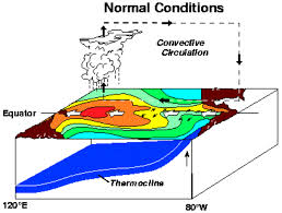
The key driving factors on rainfall systems over Malawi include the Sea Surface Temperatures (SSTs) over the Pacific, Indian and Atlantic tropical Oceans. Global models are currently projecting the development of moderate El Nino conditions between September and November 2018 which are likely to persist throughout the 2018/2019 rainfall season. An El Nino phenomenon is the unusual warming of waters over the Eastern Central Equatorial Pacific Ocean and is known to influence rainfall patterns across the world including Southern Africa and Malawi.
Since the year 2000, El Nino events have been observed in 2002-2003, 2004-2005, 2006-2007, 2009-2010, 2014-2015 and 2015-2016 seasons. Of these, only 2002-2003 and 2009-2010 were affected by moderate El Nino similar to the 2018/2019 season. Climatic analyses on these moderate El Nino years show that the country received generally normal cumulative rainfall amounts and early onset in the northern half and reduced cumulative rainfall amounts and normal onset in the southern half of Malawi.
Based on the observations and analyses in Malawi, with further additional input from consensus forecast from the climate experts meeting that took place in Gaborone Botswana and discussed at the 22nd Southern Africa Regional Climate Outlook Forum (SARCOF-22) in Lusaka, Zambia, the seasonal rainfall forecast for 2018-2019 for Malawi is:
During the period October 2018 to March 2019, most of the northern areas spilling over into north of central areas of the country are expected to receive normal to above normal rainfall amounts, while most of the southern areas spilling over into south of central areas of the country are expected to receive normal to below normal rainfall amounts.
-AFRIEM
This implies that impacts associated with reduced or increased rainfall amounts such as prolonged dry spells and floods respectively are likely to occur during the season.
It should be noted that the forecast is relevant for relatively large areas and seasonal time scales and therefore may not fully account for all factors that influence localized climate variability, such as daily, weekly and month to month variations. The Department of Climate Change and Meteorological Services will therefore continuously issue seasonal updates, district seasonal forecasts, ten-day rainfall and Agro-meteorological bulletins, weekly forecasts, five-day and daily forecasts, as well as monitor and issue advisories on the development and movement of the tropical cyclones over the South West Indian Ocean during the 2018/2019 rainfall season.
Users from the agricultural sector are encouraged to seek advice from the Ministry of Agriculture, Irrigation and Water Development when applying this forecast in decision making such as when to plant.
Cover Image Credit: AFRIEM
Categories: Forecasting


