Excerpts from Geo-Mexico
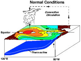
La Niña and El Niño are two major periodic disturbances to the normal oceanic and atmospheric circulation patterns over the Pacific Ocean which have widespread effects around the world. The normal circulation in the equatorial Pacific (the Walker circulation cell) results from a low pressure area over the western Pacific (due to warm surface ocean temperatures) and a high pressure area over the eastern Pacific (due to the upwelling of cold ocean water off the coast of Ecuador). Surface trade winds blow from east to west, while high altitude air flow is from west to east.
A La Niña event is an intensification of the normal Walker cell. This results in warmer and drier conditions than normal, rarely with serious consequences for Mexico.
However, during an El Niño Southern Oscillation (ENSO) event, the Walker circulation pattern is essentially reversed. Early in the year, warm ocean water extends much further east, causing warm moist air to rise off the coast of South and Central America, bringing heavy rainfall to areas along the west coast of Mexico. The El Niño in 1998 raised the temperature of water off Mexico’s Pacific coast by some 3° to 5°C (6° to 9°F) and also increased the humidity considerably. Historically, ENSO events have occurred every four to seven years, but their frequency may now be increasing.
The effects of an ENSO event are also felt on the Gulf coast. The low pressure area resulting from the air rising off the western coast causes air from further east to be dragged across Mexico. This means that more cold fronts or nortes enter north and central Mexico. Winter precipitation in these areas increases significantly, especially in the north, and temperatures are much cooler than usual. Flooding can result in coastal areas. ENSO effects are also felt in other parts of the world.
In Mexico, ENSO events not only affect winter precipitation but also summer precipitation, which is more critical for farmers. This is because they push the equatorial Intertropical Convergence Zone (ITCZ), where the north-east and south-east trade winds meet, further south. This reduces the convective activity and rainfall in Mexico’s central highlands. Furthermore, this may reduce cloud cover and therefore increase solar radiation and evapotranspiration, making the ground even drier.
In summary, subsistence corn (maize) farmers find that their cooler, wetter winter than normal is immediately followed by a hotter and drier summer growing season. This can have disastrous consequences for their food security. The rapid onset of changed conditions does not allow much time for adequate adjustments to be made to their choice of crops or farming methods.
Historical analysis combined with greater climatological understanding shows that many of the worst droughts and floods in Mexico have been associated with either ENSO events or with the related Pacific-North American Oscillation. Perhaps 65% of the variability of Mexican climate results from changes in these large-scale circulations.
Cover Image: Time